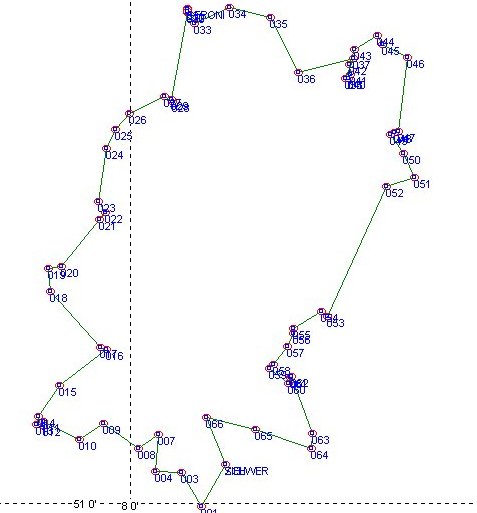
We will visit some lakes (Biggesee, Sorpesee, Moehnesee) and the National Park called 'Arnsberger Wald'
only on twisting and winding roads.
Time is scheduled for about 6 hours without breaks.
Total Distanz is 270 km.
|
WayPoint |
Distanz |
km - total |
Direction |
Description - sign |
Longitude |
Latitude |
|
SCHWER |
0,0 |
0,0 |
right |
Hilchenbach |
8.14956 |
51.03843 |
|
001 |
8,8 |
8,8 |
right |
Kirchhundem |
8.11218 |
50.99712 |
|
003 |
6,1 |
14,9 |
left |
Silberg |
8.08061 |
51.03058 |
|
004 |
3,2 |
18,1 |
right |
Kirchhundem |
8.03896 |
51.03178 |
|
007 |
4,7 |
22,8 |
left |
Kreutztal / Krombach |
8.04348 |
51.06847 |
|
008 |
3,0 |
25,8 |
right |
Bus-Stop |
8.01182 |
51.05388 |
|
009 |
5,5 |
31,3 |
left |
no sign -> Olpe |
7.9564 |
51.07909 |
|
010 |
3,5 |
34,8 |
right |
Attendorn / Biggesee |
7.91784 |
51.06315 |
|
011 |
6,1 |
40,9 |
left |
Attendorn |
7.86105 |
51.08076 |
|
012 |
0,6 |
41,5 |
right |
Attendorn |
7.86199 |
51.07685 |
|
013 |
0,9 |
42,4 |
right |
Attendorn |
7.85086 |
51.078 |
|
014 |
1,0 |
43,4 |
STOP |
Biker-Meeting-Point Biggesee |
7.85311 |
51.08655 |
|
015 |
5,1 |
48,4 |
straight on |
Finnentrop |
7.88721 |
51.11731 |
|
016 |
8,4 |
56,8 |
left |
Ennest (ARAL) |
7.96111 |
51.15292 |
|
017 |
1,0 |
57,8 |
right |
Hülschotten -> Plettenberg |
7.95123 |
51.15419 |
|
018 |
12,4 |
70,2 |
right |
Lennestadt |
7.8716 |
51.21012 |
|
019 |
3,0 |
73,2 |
left |
Lennestadt B236 |
7.86978 |
51.23351 |
|
020 |
1,8 |
75,0 |
left |
Arnsberg / Allendorf |
7.89029 |
51.235 |
|
021 |
11,0 |
86,0 |
left |
Sorpesee |
7.95001 |
51.28171 |
|
022 |
1,1 |
87,1 |
left |
Sorpesee / Balve |
7.95905 |
51.28929 |
|
023 |
1,4 |
88,5 |
right |
Sorpesee / Hachen |
7.94925 |
51.29971 |
|
024 |
7,9 |
96,4 |
STOP |
Biker-Meeting-Point Sorpesee |
7.96085 |
51.35233 |
|
025 |
3,6 |
100,0 |
right |
Neheim-Hüsten / Arnsberg |
7.97602 |
51.37098 |
|
026 |
2,4 |
102,4 |
right |
Wenningloh |
7.99787 |
51.38688 |
|
027 |
6,0 |
108,4 |
right |
Zentrum / Arnsberg |
8.05415 |
51.40404 |
|
- |
1,0 |
109,4 |
straight on |
Soest |
- |
- |
|
- |
0,3 |
- |
straight on |
Tunnel |
- |
- |
|
028 |
0,0 |
109,7 |
left |
Soest |
8.06602 |
51.39904 |
|
029 |
0,5 |
110,2 |
left |
Möhnesee B229 |
8.06455 |
51.40086 |
|
030 |
12,2 |
122,4 |
left |
- |
8.08965 |
51.48808 |
|
GERONI |
0,2 |
122,6 |
right |
- |
8.08982 |
51.49119 |
|
031 |
0,0 |
122,8 |
STOP |
GERONIMO Cafe - Restaurant |
8.09021 |
51.49058 |
|
032 |
0,2 |
123,0 |
right |
Südufer |
8.08954 |
51.48872 |
|
033 |
2,0 |
125,0 |
left |
Südufer / Stockum |
8.1011 |
51.47671 |
|
034 |
5,0 |
130,0 |
right |
Niederbergheim |
8.15594 |
51.4921 |
|
035 |
6,1 |
136,1 |
right |
Hirschberg / Meschede |
8.22123 |
51.48238 |
|
036 |
9,1 |
145,2 |
left |
Meschede |
8.2655 |
51.42756 |
|
037 |
7,8 |
153,0 |
right |
Meschede |
8.35322 |
51.44171 |
|
038 |
2,5 |
155,5 |
left |
Warsteiner Brauerei |
8.34016 |
51.42169 |
|
040 |
0,4 |
155,9 |
left |
Gästehaus Waldfrieden |
8.34532 |
51.42216 |
|
041 |
0,5 |
156,4 |
left |
NOT Gästehaus Waldfrieden |
8.3486 |
51.42618 |
|
042 |
1,1 |
157,5 |
right |
Warstein |
8.34757 |
51.4363 |
|
043 |
1,8 |
159,3 |
right |
Rüthen |
8.35573 |
51.45066 |
|
044 |
3,6 |
162,9 |
right |
Kallenhardt |
8.39147 |
51.46426 |
|
045 |
1,0 |
163,9 |
left |
Nuttlar |
8.39869 |
51.45617 |
|
046 |
3,9 |
167,8 |
right |
Nuttlar |
8.43938 |
51.44265 |
|
047 |
11,3 |
179,1 |
right |
Meschede |
8.42476 |
51.36972 |
|
048 |
0,5 |
179,6 |
right |
Meschede |
8.41848 |
51.36875 |
|
049 |
0,8 |
180,4 |
left |
Fort Fun |
8.41231 |
51.36607 |
|
050 |
4,1 |
184,5 |
right |
Fort Fun |
8.43355 |
51.34703 |
|
051 |
3,0 |
187,5 |
right |
Fort Fun |
8.44958 |
51.32336 |
|
052 |
4,2 |
191,7 |
left |
Westernbödefeld / Bad Fredeburg |
8.40521 |
51.31468 |
|
053 |
18,4 |
210,1 |
right |
Meschede |
8.31263 |
51.18561 |
|
054 |
0,9 |
211,0 |
left |
Wormbach |
8.30307 |
51.19014 |
|
055 |
4,0 |
215,0 |
left |
Wormbach |
8.25785 |
51.17373 |
|
056 |
0,8 |
215,8 |
straight on |
Werpe |
8.25794 |
51.16836 |
|
057 |
1,7 |
217,5 |
straight on |
Harbecke |
8.2489 |
51.15569 |
|
058 |
4,5 |
222,0 |
right |
Lenne |
8.2262 |
51.1378 |
|
059 |
0,7 |
222,7 |
left |
Lenne |
8.21997 |
51.1339 |
|
060 |
2,2 |
224,9 |
left |
Gravel-Road -> Fleckenburg |
8.25044 |
51.11884 |
|
061 |
1,5 |
226,4 |
right |
(Back on Asphalt) |
8.25383 |
51.12531 |
|
062 |
0,3 |
226,7 |
right |
- |
8.25513 |
51.12539 |
|
063 |
9,2 |
235,9 |
right |
Aue |
8.28898 |
51.06918 |
|
064 |
1,0 |
236,9 |
right |
Kirchhundem |
8.28636 |
51.05443 |
|
065 |
13,0 |
249,9 |
STOP |
Biker-Meeting Point Rhein-Weser Turm |
8.19819 |
51.0728 |
|
066 |
10,0 |
259,9 |
left |
Heinsberg |
8.12019 |
51.0854 |
|
ZIEL |
8,0 |
267,9 |
STOP |
Hotel Schwermer |
8.14956 |
51.03843 |
Waypoints:
Get WayPoint+ File for GARMIN GPS
Get WayPoint+ and look at the Famous GARMIN Page of Thomas Born atic#3
Collected, written and driven by Stefan Schneider