San Gottardo - Sankt Gotthard
 |
Switzerland/ San Gottardo - Sankt Gotthard |
tour provided by: Adrian Burkert |
Tour
San Gottardo - Sankt Gotthard
Data
| Height of pass: |
2109 m |
|
| Slope: |
10 % |
|
| # of turns: |
|
|
| Best season: |
|
|
| Time: |
17 min / 46 min |
tunnel / pass |
| Distance: |
25.2 km / 34.1 km |
tunnel / pass |
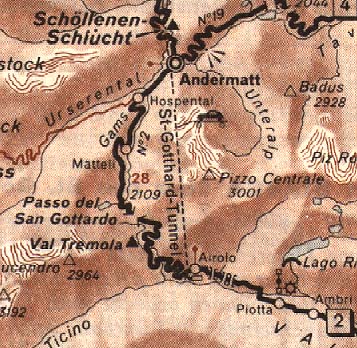
| Roadmap: |
Map of the trip |
GPS Data |
| Location |
Coordinate [WGS84] |
Type |
Services |
| Wassen |
46° 42' 07.9'' N 008° 35' 34.3'' E |
town |
all services |
| Andermatt |
46° 37' 54.7'' N 008° 36' 00.1'' E |
village |
all services |
| Airolo |
46° 31' 43.1'' N 008° 36' 39.7'' E |
village |
all services |
| San Gottardo pass |
46° 43' 44.3'' N 008° 11' 11.6'' E |
pass |
restaurant, restrooms |
Pictures
General information
The Gotthard is the most important, the
most controverse and the most traditional pass in Switzerland - it is a
symbol for the 'victory of man against nature' (why not the way man
has learned to live with nature ? - well this would lead to a longer discussion,
so back to the history).
Ever since the postal horsecars crossed
it became a legend. Then the railway tunnel, later the road tunnel and
the new pass road was built and in future maybe even the NEAT (new european
alp transit for trains.
First of all all the roads are in excellent
state !
You have three possibilities to conquer
the mountain:
1. the tunnel - autobahn, you need the
vignete (a lot of police controls for the vignette here)
2. the new pass road - almost an autobahn
over the hill
3. the old pass road
I will only describe the old pass road
- 'cause this the road to ride !!!
Road description
From Andermatt follow the signs to the
San Gottardo. After a while you turn right from the asphalt road to get
on the old pass road, which was built 1830 but renovated a few years ago.
Don't panic - it's just the old paving
stone road, really great fun to ride ! From here up to the pass you have
a lot of easy curves to get used to the ground and the funny noise your
tires make when laying down in them ...
On the pass there are tourist shops and
restaurants, then the road winds down hairpin after hairpin to the Tremola
canyon.
WWW Links
© by Atic.org in Okt. 1999