Sattelegg Ibergeregg Sattel Etzel
 |
Switzerland/ Sattelegg Ibergeregg Sattel Etzel |
tour provided by: Adrian Burkert |
Tour
Sattelegg - Ibergeregg - Sattel - Etzel
A nice tour you can do in
an afternoon (about 2 1/2 hours) brings you from the north to the heart
of Switzerland and back. These are four little passes but there are some
very twisty roads to ride !!!
Data
Time: 2.5hours
Distance: 100km
Sattelegg
Data
| Height of pass: |
1190m |
|
| Slope: |
14% |
|
| # of turns: |
|
|
| Best season: |
almost all year |
|
| Time: |
see route |
|
| Distance: |
see route |
|
| Roadmap: |
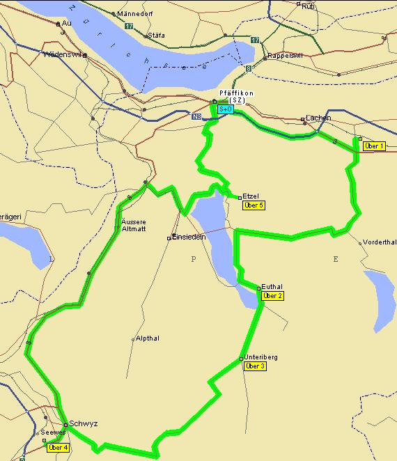
Map of the trip |
GPS Data |
| Location |
Coordinate [WGS84] |
Type |
Services |
| Sattelegg |
47°07'37.0'' N / 008°50'44.1''E |
Pass |
Restaurant |
| Pfäffikon SZ |
47°12'12.0'' N / 008°47'28.6''E |
Village |
All services |
General information
The quality of the road is moderate-good.
A fast ride with some surprising turns ;-) .
Road description
[from Pfäffikon SZ to ]
Follow the main road to Siebnen then turn
right into the valley. After the tunnels fun starts - light and shadow,
dry and wet road, small and wide turns follow very fast. The pass height's
restaurant is surrounded by green meadows - but shortly after that you're
in the forrest again.
Ibergeregg
Data
| Height of pass: |
1406m |
|
| Slope: |
14% |
|
| # of turns: |
|
|
| Best season: |
|
|
| Time: |
see route |
|
| Distance: |
see route |
|
| Roadmap: |
Map of the trip |
GPS Data |
| Location |
Coordinate [WGS84] |
Type |
Services |
| Ibergeregg |
47°00'20.6'' N / 008°43'44.4''E |
Pass |
Restaurants, restrooms, picnic area, hiking |
| Schwyz |
47°01'17.0'' N / 008°39'24.8''E |
City |
all services |
General information
Road conditions change a lot from moderate to good.
Road description
[heading to Schwyz]
The pass road starts easy - nothing spectacular
- but then some very nice turns lead you up the hill through the forests.
At once you can spot a very nice shaped peak thought the trees - the road
passes it (picnic area) and you reach the pass height.
Downhills the road gets very narrow and
twisty (yeah - that's what we like !!!) - take care of cars diving up,
they might be cutting the curves !
Sattel
Data
| Height of pass: |
932m |
|
| Slope: |
|
|
| # of turns: |
|
|
| Best season: |
Summer, autumn |
|
| Time: |
see route |
|
| Distance: |
see route |
|
| Roadmap: |
Map of the trip |
GPS Data |
| Location |
Coordinate [WGS84] |
Type |
Services |
| Sattel |
47°05'00.0'' N / 008°38'00.0''E |
Pass |
Restaurant |
| Rotenthurm |
47°06'25.0'' N / 008°40'30.4''E |
|
Restaurant, gas |
| Biberbrugg |
47°09'27.4'' N / 008°43'26.8''E |
|
Restaurants, gas station |
| Schwyz |
47°01'17.0'' N / 008°39'24.8''E |
City |
all services |
General information
Road condition: very good !!!
Although the road looks like a racetrack
the speed limit of 80km/h is checked by police very often !!!
Near Rothenturm is a nature reservation
- one of the last high bog ecosystems in Switzerland - worth a hike !
Rothenturm is also famous for it's moto
cross championships (in autumn).
Road description
[from Schwyz to Biberbrugg]
Follow the roadsigns to Rothenturm - the
road leads outside the city and up the hill. Stop at the vista points -
you'll have a fantastic view into the heart of Switzerland !!! When there
is fog in the valley or some fuzzy clouds cover part of the mountains you
get a picture of the wild but beautyful Innerschweiz.
The route gets a little bit boring (straight,
flat) but this is compensated by the areas flora and fauna so take it easy
and have a picnic or a short hike. From Rothenturm you follow the main
road all the way to Biberbrugg.
Etzel
Data
| Height of pass: |
950m |
|
| Slope: |
15% |
|
| # of turns: |
|
|
| Best season: |
all year |
|
| Time: |
see route |
|
| Distance: |
see route |
|
| Roadmap: |
Map of the trip |
GPS Data |
| Location |
Coordinate [WGS84] |
Type |
Services |
| Etzel |
47°10'25.5'' N / 008°46'22.8''E |
Pass |
Restaurant |
| Pfäffikon SZ |
47°12'12.0'' N / 008°47'28.6''E |
Town |
All services |
General information
The road is rated bad-moderate.
All in all a short & funny ride (about 20min).
Road description
[from Biberbrugg to Pfäffikon]
Turn right in Biberbrugg, then follow the
signs to Einsiedeln. After a few km turn left to Etzelpass, the first part
was gravel on a Sunday in September '97, then asphalt. After a short while
you reach the pass heigh with a restaurant - from there it winds down in
a few serpentines (craziest turns I've seen so far in the region !!! also
very steep) to Pfäffikon SZ.
Sights
in the area
- The Hölloch caves are supposed to be
one of the biggest cave systems of the world (more than 160km, only 1km
for open to public). Open all day except Monday and Tuesday - but still
do check in advance (telefone number is +41-(0)43-712771). You'll see Stalaktites/Stalagmites,
an underground river and some or the caves animals. From Altdorf to Brunnen,
Schwyz, Unteriberg then follow the Hölloch Cave signs.
- The church in Einsiedeln was built in the
18th century and is a famous pilgrims place, who want to see the black
madonna and the nice nice paintings and Stukkaturen at the walls.
- The three cantons of Uri, Schwyz and Unterwalden
founded Switzerland in 1291 - the saga made famous by the German poet Friedrich
Schiller ('William Tell' - Swiss national hero) so it's no wonder that
there are many museums, places and Sights related to Swiss history in the
area around Altdorf (which is the capitol of the canton of Schwyz)
WWW Links
© by Atic.org in Okt. 1999