Bernina pass
 |
Switzerland/ Bernina pass |
tour provided by: Adrian Burkert |
Jump directly to ...
Tour
Bernina
Data
| Height of pass: |
2328 m |
|
| Slope: |
12 % |
|
| # of turns: |
|
|
| Best season: |
|
|
| Time: |
60 min |
St. Moritz - Tirano, I |
| Distance: |
53.4 km |
St. Moritz - Tirano, I |
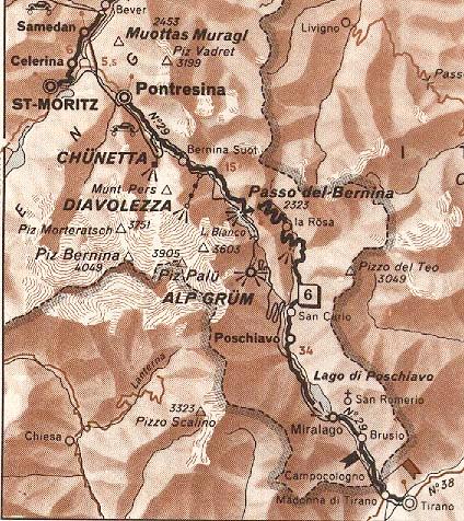
| Roadmap: |
Map of the Berninapass |
GPS Data |
| Location |
Coordinate [WGS84] |
Type |
Services |
| St. Moritz |
46° 29' 51.9'' N 009° 50' 25.1'' E |
town |
all services |
| Tirano |
46° 12' 59.8'' N 010° 10' 04.4'' E |
city |
all services |
Camping
Sights in the area
General information
Road condition: good
Bernina is a continental water divide:
The water from the one lake on top flows into the Black Sea, the water
from the other into the Atlantic
Road description
After St. Moritz the road leads into a
valley with nice forests and little rivers. Be sure to stop from time to
time for a view or even a short hike or a picknick. Take care at the railwaycrossing:
I think they wantet to build a ski jump !!! Have a break at the parking
nearby and watch the choppers grind the chromium off their bikes ... also
a nice photospot for pictures of the Bernina and the glacier.
The road itself is not very spectacular
but the landscape really is worth the ride !!!
Up at the pass there is a restaurant and
a big parking with a great view of the mountains.
WWW Links
Pictures
© by Atic.org in Okt. 1999
|