|
|
|
|
|
|
|
|
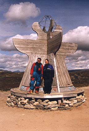
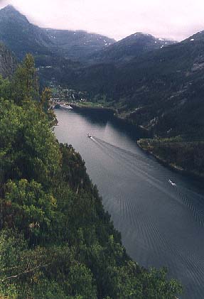
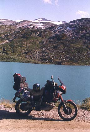
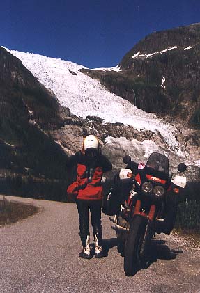
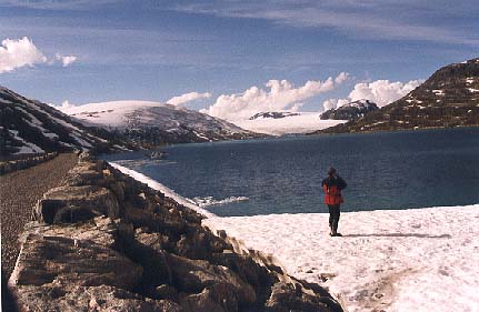
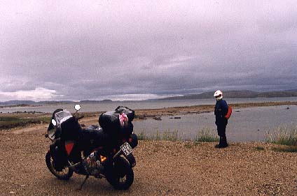
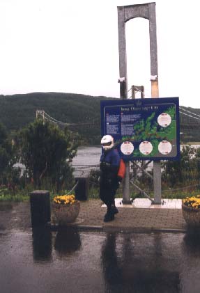
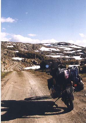
Jump directly to ... The summer 99 Tour from north to south We arrived at Norway in the far north at KARIGASNIEMI 18 km away from KARASJOK. It was raining and very cold, but we wanted to go to the NORTH CAPE. We followed the E 6 to LAKSELV there we reached the sea. Near RUSSENES the road splits up. Left it is going to HAMMERFEST and ALTA, straight the last 110 km to the most north point in Europe. The road follows the coast nearly all the time. We had heavy cold wind and rain all the time. After 75 km you reach the new "tunnel", no more ferries are going. At the end of the tunnel you have to pay. 100,- NKr. for a bike and two persons (60,- bike + 1 Per.). You have to pay again on the way back!! At the island, behind the tunnel, you reach HONNIGSVAG, chance to get gasoline and something to eat, also Hotels. Then you have to go 35 more km till the next toll station. To reach the end of the "cap" you have to pay another 175,- NKr. per person. This includes entrance to all buildings and possibility to stay over night. We didn't pay that and moved back. We spend the night in RUSSENES in a cabin, because my girl was really freezing. Next day we took the E 6 down to ALTA. There we decided to leave the E 6 and take the way through Finland and Sweden back to Norway. We took rd. nr. 93 to MASI and KAUTOKEINO to the finnish border. 220 km with 3 little towns. very lonely. We came back to Norway near NARVIK from KIRUNA (Sweden). The way down from RIKSGRÄNSEN was very nice for me, a lot of rocks near the street and at the end down to the sea. We didn't go to NARVIK because we take the E 6 right to BJERKVIK to reach the LOFOTEN and VESTERALEN. So we went left in Bjerkvik on the E 10. The road follows the coastline and sometimes it is going up a bit into the mountains. After 66 km you are going to the first island over a nice bridge. We took the way left direction LODINGEN and on, again over a bridge to SORTLAND, where we spent the night (we meet Davide and his Varadero). Next day we took a ride north on 820 and 821 to MYRE, again in rain. In MYRE you can find another road to the most northern point of this island. There they offer some "Whale-watching-boat-tours". Because of the bad weather we went down to LODINGEN again to take the ferry back to BOGNES. The very nice boat trip least 1 hour. From BOGNES we took the boring E 6 to come down fast. Before FAUSKE we passed another toll station. After FAUSKE the road leaves the coast and climbs up some hills. A very nice landscape. After ROKLAND the "SILVER VÄGEN" (fin. SININEN TIE) leaves to the left. This is a traditional road to Russia. The E 6 crosses the "SALTFJELLET". At the end of the mountains, when the road start to go down to MO I RANA we crossed the "ARCTIC CIRCLE" again. There is a souvenir shop near the parking and a small museum. We meet a lot of bikers there - of course. In MO I RANA we decided to leave NORWAY again, because I found it boring to follow the E 6 the hole time. So we took the E 12 (the BLA VEGEN) to SWEDEN. The road goes up to the hills and we left Norway at UMBUKTA. We came back to NORWAY at ROROS, south of TRONDHEIM, on rd 31. There we started a "zick-zack-curse". From ROROS left down to OS, on rd 30 down to ALVDAL, then right to FOLLDAL on rd 29. This road ends at the E 6 near the DOVREFJELL national park. We went left to DOMBAS. From here north west again, 107 km on rd 9, to ANDALSNES. Here one of the nicest parts of our trip began. Out of ANDALSNES-camping the road 63 takes us up on the "TROLLSTIEGEN" to 1788m. At the top is a view point and you can watch a big waterfall. (3 days after we passed the road it has been closed till next year, because some rocks might fall on the road and they will fix it). The way down took us to another high valley and then down again. Over a bridge near some houses you can watch another very nice waterfall. (Sometimes children sell self-made waffles). At the ground you reach another FJORD and cross it near LINGE to EIDSDAL. The road 63 takes you up again. Then the road goes down to the GEIRNAGER FJORD (fantastic view from a parking in a curve!!). After the town the road goes up again. At the "DJUOVASSHYTTA" in 1038 m you can take a "toll" gravel road up to the "DALSNIBBA" viewpoint in 1476 m. (we saw nothing, because of clods). A few km later we came to road 15. We went left direction LOM. After some km right on a small road (258). After a short while the road turned into a gravel road, close to the high mountains of the SOGNEFJELL / JOSTEDALSBREEN. (I think it is the biggest glacier area in Norway - to go around on normal roads you have to drive ca. 470 km). Then the road goes down again the gravel is over. After a while you pass a hotel. Here you can watch another great waterfall. (very deep!!). A bit later rd 15 is here again and we went down to STRYN. From STRYN we went left on rd 60. In OLDEN left on a one way road to BRIKSDAL to watch the very nice glacier there. (It's possible to walk on the glacier with a guide). Way back and on to BYRKJELO, left on rd 1 to SKEI. Left again along the lake and into a long tunnel. After the tunnel you see the next nice glacier near the road on the left (you can drive to a small restaurant and walk to the glacier). In FJAERLAND we didn't take the ferry, we took the toll-road to SOGNDAL and rd 55 to SOLVORN where we took the camping for some days. On the other side of the FJORD in URNES you can visit one of the famous "stave churches". Next day we went to GAUPNE. Short before we took the road left into the long valley. Near the end you can watch another famous glacier (Toll-road!!) and a glacier museum. We followed the road till the end of the valley there the road splits up. Straight is the town ELVEKROK, where the road ends. Left the road goes into another valley. A sign at the beginning warns about "road in very bad condition", but it wasn't so bad. In this valley you can see again some glaciers, then the road goes up high to a dam. Here the road ends. The third road goes up right straight into the mountains. Here the road turned fast into gravel and ended suddenly near the top of the mountain, but with a good view into the valley. The next day we made a longer trip by ferry. Back to SOGNDAL and on E 16 to KAUPANGER. Here we took the ferry to GUDVANGEN. A fantastic trip through a small Fjord. We saw some big fish near the boat. The water is 1200 m deep, and the mountains 1800 m high. Short before we arrived at GUDVANGEN the rain caught us again. So raincoat on and up to FLAM on rd 50 and AURLAND. Then on rd 288 on a fantastic small road extreme up along the Fjord with a great view on it. The road get up really high into the mountains and you have a really great view. We had some fresh SNOW there for some meters on the road before it goes down to LAERDAL. (A 25 km tunnel is planned between this two towns). Next day we followed the E 16. In BORGUND we watched a very nice "stave church". Then the road get up again into the FILLEFJELL. We went left to TYIN and took the 53 to OVRE ARDAL. Here a small tourist road takes it's way over the mountains to the rd 55. The road is a bit difficult to find. You have to go through the center and than the road goes up near a waterfall. The beginning was very difficult to ride. The curves are very small. I had problems to pass them without stopping. The toll station (like so often) is at the top of the road, where you have a great view. The road sometimes has big holes and goes down to rd 55. Then right and up again. Now the road reaches JOTUHEINEN national park. Here are the highest mountains in this area. (road can be closed from oct. - may). For a long time you will drive in the high. At the second parking we took a gravel road on the left which brought us to another dam. Same way back and down to LOM. My back tire was near the end, so we decided to go to LILLEHAMMER to get a new one. So down on road 15 till OTTA and the E 6 got us back. But not for very long. At VINSTRA we turned right and took the "PEER GYNT VEIEN". This is also a toll road, but very nice (gravel). It took us through the GUDBRANDSDALEN area. At FÄBERG we came back to E 6 and arrived at LILLEHAMMER. We found a HONDA dealer and changed tires. Then we visited the OLYMPIC PARK there. But too early to go home, so we went to west coast again. Down on E 6 till GJOVIK, then right on rd 33 till LEIRA. Here left on rd 51 to GOL. Then all the way down on rd 7 via GEILO, USTAOSSE, and 100 km through lonely mountains to EIDFJORD. A few km before near FOSSLI we saw one of the biggest waterfalls, the VORINGFOSSEN. The next 90 km the road follows the EIDFJORD and the SORFJORD. In this fjord a lot of fruits are cultivated and offered near the road. In ODDA the road leaves the fjord and goes up again. It's rd 13 now and we leave it after some km to rd 11. Before RODAL we took rd 13 again (sounds difficult, it's my Michelin map). It's a small road with lots of tunnels to SAND. The road ends in NESVIK and we have to take the ferry to HJELMELAND. Next town is TAU (on the other side STAVANGER), then JORPELAND. A view km later a small road left takes you to the "PREKESTOLEN" a very impressive viewpoint (a big rock high over LYSEFJORD - you have to walk the last 600 m up - straight up - we didn't make it with bike clothes). Road ends again in OANES and the ferry takes you to LAUVVIK. We went down to OLTEDAL and took rd 45 to DIRDAL. This is also a lonely road into the mountains. After 70 km we arrived in SVARTEVATN. We took some gasoline and the rain caught us once more. We didn't take the way to TONSTAD and moved on to the next little town there we found a empty camping and took a cabin. The next day we followed the small road through the mountains in heavy rain. Without seeing much we arrived the next valley and rd 39. We went left to VALLE. The rain stopped. Ca. 5 km behind Valle we took the rd 45 to DALEN. In EIDSBORG the next wood church. Then right on rd 11 to BRUNKEBERG. We won't go to OSLO so we went right at SELFJORD on rd 36 to BO, SKIEN and PORSGRUNN. (Toll road, free for bikes!!). Then we took the E 18 for a fast ride up till we left it to HORTEN. Here is a ferry to the other side and you can avoid crossing OSLO if you want (we wanted). The ferry takes you to MOSS. The boring E 6 brought us down to Sweden. Prices have been between between 75,- and 120,- NKr. for tent + bike + 2 Persons. For cabins we paid between 180,- and 350,- NKr.(see also the complete tour)
Pictures Pictures of Norway
Picture-Count: 12
|